![](/images/other/stat-length.png)
![Randonnée Marche Le Tampon - Randos Festives : La Boucle du Piton Guichard - Photo](https://media.geolcdn.com/t/1900/400/8cba512f-4604-4cd8-ab6d-fd39497d815a.jpg&format=pjpeg&maxdim=2)
Randos Festives : La Boucle du Piton Guichard
GilbertLP
Utilisateur
![Longueur](/images/other/stat-length.png)
Longueur
11,6 km
![Altitude max](https://static1.geolcdn.com/siteimages/upload/files/1508320355ic_sort_altitude_max_24dp.png)
Altitude max
1858 m
![Dénivelé positif](https://static1.geolcdn.com/siteimages/upload/files/1508320355ic_sort_den_pos_24dp.png)
Dénivelé positif
371 m
![Km-Effort](/images/other/stat-length.png)
Km-Effort
16,5 km
![Altitude min](https://static1.geolcdn.com/siteimages/upload/files/1508320355ic_sort_altitude_min_24dp.png)
Altitude min
1577 m
![Dénivelé négatif](https://static1.geolcdn.com/siteimages/upload/files/1508320355ic_sort_den_neg_24dp.png)
Dénivelé négatif
370 m
![Boucle](https://static1.geolcdn.com/siteimages/upload/files/16400158638029165_repeat_loop_refresh_sync_direction_icon.png)
Boucle
Oui
Date de création :
2020-09-04 11:45:11.793
Dernière modification :
2020-09-04 12:18:35.028
![Marche](https://static1.geolcdn.com/sitytour/trail-icons/101.png)
3h28
Difficulté : Difficile
![Scannez ce code QR pour ouvrir la randonnée dans l'application SityTrail](https://capi.geolives.com/qq0zvz2zws4bq2lad0pu/sitytour/trails/2537572/qr.png?size=200)
Application GPS de randonnée GRATUITE
À propos
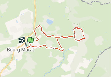
Randonnée Marche de 11,6 km à découvrir à La Réunion, Inconnu, Le Tampon. Cette randonnée est proposée par GilbertLP.
Description
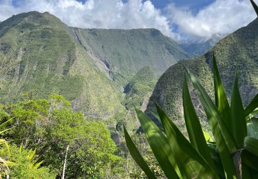
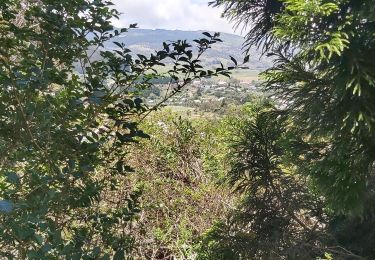
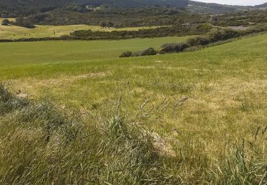
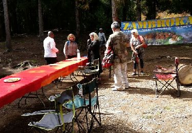
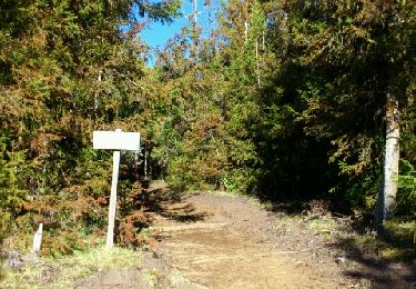
Chemins de traverse propose cette randonnée dans le cadre des Randos Festives 2020, le 11 octobre 2020. Elle permet d'avoir une vue de toute la Plaine des Cafres en prenant de la hauteur en montant au Piton Guichard, situé à l'entrée de la belle forêt des Trous Blancs.
Localisation
Pays :
France
Région :
La Réunion
Département/Province :
Inconnu
Commune :
Le Tampon
Localité :
Unknown
Départ:(Dec)
Départ:(UTM)
352077 ; 7654519 (40K) S.
Commentaires
Randonnées à proximité
![Randonnée Marche Le Tampon - Grand Bassin à partir de Bois Court - Photo](https://media.geolcdn.com/t/375/260/546c7d2f-db6d-45ed-ad24-b006fb8e00d4.jpg&format=jpg&maxdim=2)
![Marche Marche](https://static1.geolcdn.com/sitytour/trail-icons/101.png)
Grand Bassin à partir de Bois Court
Marche
Difficile
(1)
Le Tampon,
La Réunion,
Inconnu,
France
![](/images/other/stat-length.png)
9,5 km | 22 km-effort
4h 23min
![](https://static1.geolcdn.com/siteimages/upload/files/16400158638029165_repeat_loop_refresh_sync_direction_icon.png)
Oui
![Randonnée Trail Le Tampon - Voile de la Mariée par Grand Bassin - Photo](https://media.geolcdn.com/t/375/260/5427d8f3-02fa-4d1e-bfb5-4fd763fbd394.jpg&format=jpg&maxdim=2)
![Trail Trail](https://static1.geolcdn.com/sitytour/trail-icons/104.png)
Voile de la Mariée par Grand Bassin
Trail
Difficile
Le Tampon,
La Réunion,
Inconnu,
France
![](/images/other/stat-length.png)
10,4 km | 25 km-effort
3h 20min
![](https://static1.geolcdn.com/siteimages/upload/files/16400158638029165_repeat_loop_refresh_sync_direction_icon.png)
Oui
![Randonnée A pied Le Tampon - 3 pitons à Bourg Murat - Photo](https://media.geolcdn.com/t/375/260/970bad91-7bf9-4096-b52f-d8b7555be2f2.jpg&format=jpg&maxdim=2)
![A pied A pied](https://static1.geolcdn.com/sitytour/trail-icons/100.png)
3 pitons à Bourg Murat
A pied
Moyen
Le Tampon,
La Réunion,
Inconnu,
France
![](/images/other/stat-length.png)
12,4 km | 16,4 km-effort
Inconnu
![](https://static1.geolcdn.com/siteimages/upload/files/16400158638029165_repeat_loop_refresh_sync_direction_icon.png)
Oui
![Randonnée Marche Le Tampon - bourg murat la fournaise - Photo](https://media.geolcdn.com/t/375/260/90df9966-627c-4173-ae45-ca4957fd7ec0.jpg&format=jpg&maxdim=2)
![Marche Marche](https://static1.geolcdn.com/sitytour/trail-icons/101.png)
bourg murat la fournaise
Marche
Difficile
Le Tampon,
La Réunion,
Inconnu,
France
![](/images/other/stat-length.png)
19,1 km | 29 km-effort
7h 38min
![](https://static1.geolcdn.com/siteimages/upload/files/16400158638029165_repeat_loop_refresh_sync_direction_icon.png)
Non
![Randonnée Marche Le Tampon - grand bassin mollaret piton rando - Photo](https://media.geolcdn.com/t/375/260/ext.jpg?maxdim=2&url=https%3A%2F%2Fstatic1.geolcdn.com%2Fsiteimages%2Fupload%2Ffiles%2F1553511878bg_sport_marche.png)
![Marche Marche](https://static1.geolcdn.com/sitytour/trail-icons/101.png)
grand bassin mollaret piton rando
Marche
Difficile
(1)
Le Tampon,
La Réunion,
Inconnu,
France
![](/images/other/stat-length.png)
18,9 km | 37 km-effort
7h 30min
![](https://static1.geolcdn.com/siteimages/upload/files/16400158638029165_repeat_loop_refresh_sync_direction_icon.png)
Oui
![Randonnée Marche Le Tampon - Murat nez de bœuf - Photo](https://media.geolcdn.com/t/375/260/ext.jpg?maxdim=2&url=https%3A%2F%2Fstatic1.geolcdn.com%2Fsiteimages%2Fupload%2Ffiles%2F1553511878bg_sport_marche.png)
![Marche Marche](https://static1.geolcdn.com/sitytour/trail-icons/101.png)
Murat nez de bœuf
Marche
Très facile
(1)
Le Tampon,
La Réunion,
Inconnu,
France
![](/images/other/stat-length.png)
15,9 km | 23 km-effort
5h 23min
![](https://static1.geolcdn.com/siteimages/upload/files/16400158638029165_repeat_loop_refresh_sync_direction_icon.png)
Oui
![Randonnée Marche Le Tampon - Trous Blancs de Piton Sec - Photo](https://media.geolcdn.com/t/375/260/ext.jpg?maxdim=2&url=https%3A%2F%2Fservices.sitytrail.com%2FGeolivesWS%2FDownloadMedia.ashx%3FTrailID%3D452656%26Media%3Dfix__20150730105930.jpg)
![Marche Marche](https://static1.geolcdn.com/sitytour/trail-icons/101.png)
Trous Blancs de Piton Sec
Marche
Facile
(1)
Le Tampon,
La Réunion,
Inconnu,
France
![](/images/other/stat-length.png)
3,9 km | 6,1 km-effort
3h 4min
![](https://static1.geolcdn.com/siteimages/upload/files/16400158638029165_repeat_loop_refresh_sync_direction_icon.png)
Oui
![Randonnée Marche Le Tampon - La Réunion - Boucle des sources du Bras de Pontho par le Piton Guichard - Photo](https://media.geolcdn.com/t/375/260/ext.jpg?maxdim=2&url=https%3A%2F%2Fservices.sitytrail.com%2FGeolivesWS%2FDownloadMedia.ashx%3FTrailID%3D315245%26Media%3Dfix__20140622155133.jpg)
![Marche Marche](https://static1.geolcdn.com/sitytour/trail-icons/101.png)
La Réunion - Boucle des sources du Bras de Pontho par le Piton Guichard
Marche
Moyen
Le Tampon,
La Réunion,
Inconnu,
France
![](/images/other/stat-length.png)
6,3 km | 9,8 km-effort
2h 3min
![](https://static1.geolcdn.com/siteimages/upload/files/16400158638029165_repeat_loop_refresh_sync_direction_icon.png)
Non
![Randonnée Marche Le Tampon - Coteau Maigre - Photo](https://media.geolcdn.com/t/375/260/ext.jpg?maxdim=2&url=https%3A%2F%2Fstatic1.geolcdn.com%2Fsiteimages%2Fupload%2Ffiles%2F1553511878bg_sport_marche.png)
![Marche Marche](https://static1.geolcdn.com/sitytour/trail-icons/101.png)
Coteau Maigre
Marche
Difficile
(2)
Le Tampon,
La Réunion,
Inconnu,
France
![](/images/other/stat-length.png)
16,8 km | 26 km-effort
5h 26min
![](https://static1.geolcdn.com/siteimages/upload/files/16400158638029165_repeat_loop_refresh_sync_direction_icon.png)
Oui